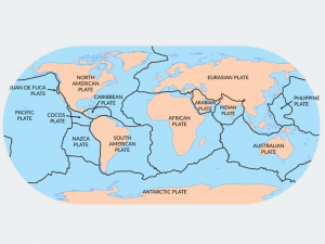
7 Major Tectonic Plates: The World’s Largest Plate Tectonics

The World’s Largest Plate Tectonics
Earth has 7 major plate tectonic boundaries and 10 or so minor ones.
Plate tectonics have deceptively slow movement. Just centimeters each year. But they’re never idle.
Like the seams of a baseball, tectonic plate boundaries wrap around the Earth.
Earth’s tectonic plate boundaries are unusual because they can consist of continent and ocean crust.
Here are the 7 major tectonic plates of the world in a bit more detail.
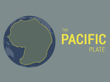
1. Pacific Plate

The Pacific major plate is the largest which underlies the Pacific Ocean. Specifically, it stretches all the way along the west coast of North America to the east coast of Japan and Indonesia.
This plate forms most of the Pacific Ring of Fire which has some of the most violent and catastrophic earthquakes and volcanoes on the planet.
And smack dab in the middle are the islands that make up Hawaii. The interior hot spot within the Pacific Plate is responsible for the volcanic activity that occurs in the Hawaiian Islands.
2. North American Plate
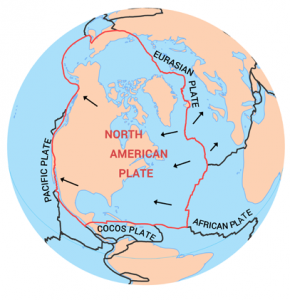
The North American major plate not only contains the continent of North America but also part of the Atlantic Ocean.
This plate extends all the way over the North Pole and even contains Siberia and the northern island of Japan. It also includes Greenland, Cuba, and the Bahamas.
The interior of the North American plate contains a giant granitic craton. It’s believed that the North American (Laurentian) craton is 4 billion years old.
3. Eurasian Plate
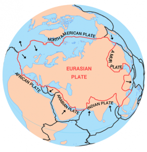
The Eurasian major plate consists of most of Europe, Russia, and parts of Asia. This plate is sandwiched between the North American and African Plates on the north and west sides.
The west side has a divergent boundary with the North American plate. The south side of the Eurasian plate neighbors the Arabian, Indian, and Sunda plates.
It straddles Iceland where it tears the country into two separate pieces at a rate of 2.5 cm per year. On average, the Eurasian plate moves about one-quarter to half an inch per year.
4. African Plate
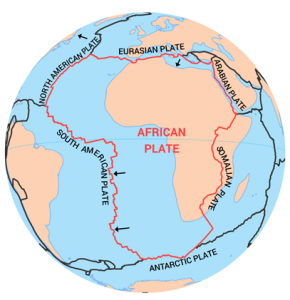
The African plate contains the whole continent of Africa as well as the surrounding oceanic crust of the Atlantic Ocean. Oddly, it looks like a larger boundary of the African continent, itself.
The Somali Plate is positioned along the East African Rift zone. This developing rift zone is gradually separating the east part of the continent.
The west side of the African major plate diverges from the North American plate. These divergent plate boundaries form the mid-oceanic ridges or rift valleys.
5. Antarctic Plate
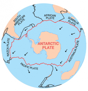
The Antarctic plate holds the entire continent of Antarctica including its surrounding oceanic crust. This plate is surrounded by parts of the African, Australian, Pacific, and South American plates.
Antarctica was once grouped as part of the supercontinent Gondwana with Australia and India. But about 100 million years ago, Antarctica broke apart to its current location at the south pole.
It’s estimated that the Antarctica major plate moves about 1 cm per year.
6. Indo-Australia Plate
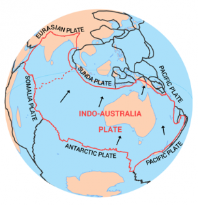
The Indo-Australia plate is a major plate combining the Australian and Indian Plates. But they are widely considered to be two separate plates.
The Indo-Australia plate stretches from Australia to India. It also includes the oceanic crust of the Indian Ocean. The northeast side of the Australian plate converges with the Pacific Plate.
Australia, India, and Antarctica were once connected as the supercontinent Gondwana. As part of the supercontinental cycle, India drifted apart moving northwards.
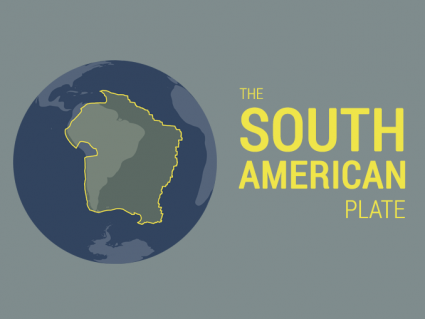
7. South American Plate
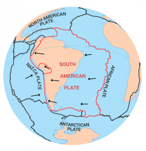
The South American plate is a major plate that includes the continent of South America and a large portion of the ocean from the Atlantic Ocean.
On the west side of South America, it experiences devastating earthquakes due to the convergent plate tectonic boundaries.
But the eastern edge lies in the Atlantic Ocean at a divergent plate boundary. Alongside the African Plate, these two plate boundaries pull apart from each other creating some of the youngest oceanic crust on the planet.
What’s the size of the 7 major tectonic plates?
| Major Plate Name | Continents and Oceans | Size (km2) |
| Pacific Plate | Pacific Ocean | 102,900,000 |
| North American Plate | United States, Canada, Arctic Ocean, and the Atlantic Ocean | 75,900,000 |
| Eurasian Plate | Europe, Russia, and Asia | 67,800,000 |
| African Plate | Africa and the Atlantic Ocean | 61,300,000 |
| Antarctic Plate | Antarctica | 60,900,000 |
| Indo-Australia Plate | Australia, India, Oceania, and the Indian Ocean | 58,900,000 |
| South American Plate | South America and the Atlantic Ocean | 43,600,000 |
The 7 Major Tectonic Plates
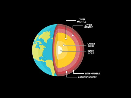
The earth’s crust is divided into plates that are made up of the original rocks of the planet.
These plates can be subducted, colliding, or sliding beside each other as they move around the earth. There are a total of seven major tectonic plates that make up our planet.
If you have any questions or comments, please feel free to contact us below and we’ll try our best to answer them.

I’m researching the African plate for a grade and this website helped a lot
Why isn’t Europe a continent like yeah it doesn’t deserve the name for it’s own name of continent. Since Asia and Europe are seperated they deserve a name.
Yes it was
Was the San Andres fault made by Tectonic plates
Europe is not a continent.
That’s why the reason for separating the Eurasian plate into Europe, Russia, and Asia is because you don’t want to call Europe Western Asia. Anyone with two working eyes can see this clearly on a map. It is located in Asia, in Europe and Russia. Why do you insist on perpetuating this geographical falsehood, which has been imposed or forcibly imposed since the 17th century? It is abundantly clear that this is not a reality. Continents are separated by tectonic plates, not oceans. The average depth of the oceans is 300 meters, but the depth of tectonic fault lines exceeds 20 kilometers. Anyway, all the continents in the world are separated by seas, so why did they come up with so many excuses to forcibly separate Europe from Asia: When mountains weren’t enough, lakes; when lakes weren’t enough, depressions; when depressions weren’t enough, rivers; when rivers weren’t enough, straits. Now, as a Turk, I want to ask this. Are the Turkish straits really just local straits within the country, or are they a barrier that starts in the northern sea, i.e., the Arctic Ocean, and ends at the Dardanelles, cutting across the continent? If the Turkish straits separated Europe and Asia, we wouldn’t encounter Europe again when we went to the east of Turkey. Moreover, there are many ethnic groups of Turkish origin in Europe. Turks are an ethnic group that has been present in Europe for thousands of years. The Hungarians, Bulgarians, Finns, Chuvash, Bashkirs, Gagauz, Karaites in Lithuania and Poland, and the peoples of the Balkans, the Caucasus, and Siberia are all of Turkish origin. Have you ever seen an Arab, Kurdish, Jewish, Indian, Iranian, or Chinese village in Eastern Europe, the Balkans, Russia, or Ukraine? But there are thousands of Turkish villages and cities in these regions.
Here’s information on the Proterozoic Eon (2500 – 541 million years ago) – https://earthhow.com/proterozoic-eon/
Tell me about An Oxygenated Atmosphere (2500 – 541 million years ago)
Thanks for the help!
Is there anywhere we can find which direction each of the plates is moving?
Thank you for the information
What would you like to know?
Hi i need more info about earthquakes where can i find them and what is the best evidence
Thanks for the info it really helped me on a report
Hi Mike, here’s some background on gravity – https://earthhow.com/how-gravity-works/
I have a question about some new material you can publish which would really help me out on my assignment. If you could, can you talk about gravity and the atmosphere? I really need some help and I would really appreciate it if you did so. Thank you.
I am very happy for knowing this information. This is because before I didn’t know how the Himalayas formed, how plates movesd, and which is the largest plate tectonic.
Thank you for this great information! I’ve always been interested in learning about the Tectonic Plates. I thank you again for the great indepth details and description that you shared about them.
It is so fascinating and thought provoking to have such insight into our beautiful planet.
Many thanks,
Susan Cromer asked whether it’s true that Iceland is the only place on Earth where two plates can be seen above ground. Iceland may be the easiest place to see two plates above ground, but it’s not the only place. The part of California west of the San Andreas Fault is on the Pacific Plate, and the area east of the fault is on the North American Plate. Also, the area west of the East African Rift Valley is on the African Plate. The area east of the rift valley is on the Somalian Plate. The Himalayas straddle the Eurasian Plate and the Indian Plate, but the boundary would be difficult to see.
I am traveling to Iceland in November and while I’d love to see Northern Lights, I am most excited about visiting the Icelandic Rift! Is it true that this is the only place on earth that you can see two plates above ground?
How do tornadoes happen?
I’m very much thankful to all those who engaged in the preparation of this more valuable information on the tectonic plates. It is more helpful indeed for those who are interested in studying earthquake plates.
It was very helpful. Thank you
It was useful for my science work
I’m interested in the geology courses
//Convection currents in the mantle result in the movement of Lithospheric plates. The motion and interactions of the plates can create patterns in the location of volcanoes and earthquakes that result along the plate boundaries.\\
Convectional currents create huge “whirls” under Lithosphere transfer tremendous heat to ocean water which generate ocean currents and cyclones over oceanic surface. This is the root cause of atmospheric changes in earth nowadays.
Thank you ?in your answer ?
Thanks. It was very helpful for my report
2022 maps have an Indian Plate and an Australian Plate as completely separate plates. Has this separation of Indo-Australia plate into two different plates been widely acknowledged?
This post was very much useful for completing my geography assignment
I would be interested on your opinion and information on the relationship between plate movements and how they are affected by gravitational influences (moon, planet and sun interactions)
Wow that was helpful for my assignment! Thanks guys.
This was very helpful information. It really helped me on my assignment. I now understand a big portion of plate tectonics!
They are made up of the oceanic crust and continental crust. The world atlas has African, Antarctica, Eurasian, Indo-Australian, North America, Pacific, and South America.
This was useful for my Geography Homework,
Thank you very much! ??
Thanks. I used to think African plate was the second and north American the third. I also used to think that Africa was the last remains of the ancient Gondwana. Do you believe that Zelandria should be included as number 8 or just be left out?
African
Antarctic
Arabian
Australian
Caribbean
Cocos
Eurasian
Indian
Juan de Fuca
Nazca
North American
Pacific
Philippine
Scotia
South American
I found it very helpful… I used this information to teach my year seven class
Been looking at 100s of images, EarthHow has by far the best in clarity and detail, THANKS!
Here’s how to cite – https://earthhow.com/how-to-cite/
Who is the author may I ask? For a research project
Please try next to put a key, so one can differentiate between the different types of plates. But it’s cool though
It would be nice if you also showed the oceans in the plate pictures
Hi I am also a student studying physical geography of the earth at the university of Goroka, and I am very much interested in knowing more about how plates move. Thank you
Sure you can 🙂
I would like to ask permission from the author if I can use the information above in my science class. Thank you very much.
Am happy to learn
Hi I was wondering how the plates completely work in FULL detail. I was wondering if you could provide me with this. Thank you.
Thanks, fixed it
For the South American Plate, I think there is a typo and suggest that you should change ‘South Africa’ to ‘South America’
Thank you!
Hi Cody. I use a GIS program to create these images. Some of the best software are QGIS and ArcGIS.
For the data, you can find a web service using this open data hub. http://hub.arcgis.com/pages/open-data
Just perform a search for plate tectonics. USGS is one of the authority sites you’ll find in your search query. I suggest to use that one for your class project.
Hi I am studying tectonic plates for my year 7 Maths assignment. I would like more information on mapping the plates and to find out how I can map and calculate these plates.