Where Is the International Date Line?
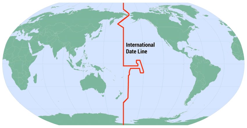
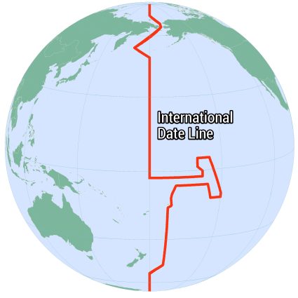
The International Date Line (IDL) is an imaginary boundary, running from the North Pole to the South Pole. It lies mainly along the 180° longitude in the Pacific Ocean.
While this line is not straight, it bends to accommodate international borders and territories. For example, it zigzags around nations like Fiji and Samoa, so travelers can keep consistent time zones.
The International Date Line is an invisible line that splits two days. It shows where one day changes to the next, helping us keep track of calendar days.
What Happens When You Cross the International Date Line?
Imagine you’re sailing across the vast, blue Pacific Ocean. As your ship glides through the waves, you approach an invisible marker, the International Date Line.
If you travel westward, it feels as if you’ve been given the gift of time, adding a whole day to your calendar. Conversely, heading eastward, you flip the calendar backward.
This happens because the Earth is divided into time zones, with the Date Line acting as a reset point. While your watch might not change, the calendar date does.
Which Countries Are Close to the International Date Line?
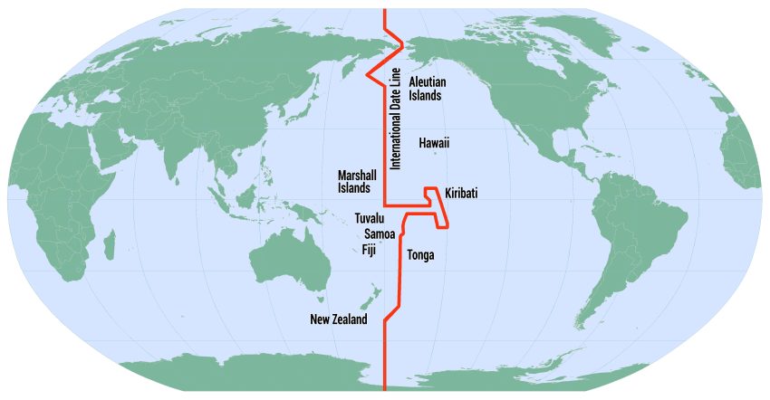
Several countries lie close to the International Date Line. Here’s a list of them and their proximity.
| Country / Territory | Description |
| Fiji | Located in the South Pacific Ocean, Fiji is an archipelago that lies to the west of the International Date Line. |
| Kiribati (Line Islands) | The Line Islands are part of Kiribati, stretching into the eastern side of the International Date Line. |
| Samoa | Samoa is situated in the central Pacific Ocean. In 2011, Samoa moved its position relative to the IDL from the east to the west. This way, it could align its workweek more closely with Australia and New Zealand. |
| Tonga | Tonga lies directly to the west of the International Date Line in the South Pacific Ocean. |
| Tuvalu | Located in the Pacific Ocean, Tuvalu is just to the west of the International Date Line. |
| United States (Alaska) | The Aleutian Islands of Alaska stretch towards the International Date Line, with some islands lying to the west of the line. |
| Russia (Chukotka & Kamchatka) | Far Eastern Russia, including the Chukotka and Kamchatka peninsulas, extends towards the International Date Line. |
| Hawaii | Although not close to the International Date Line, Hawaii lies significantly east of the International Date Line. |
| New Zealand (Tokelau) | Tokelau is a territory of New Zealand located north of Samoa and to the west of the International Date Line. |
| Marshall Islands | The Marshall Islands are situated in the central Pacific Ocean, just to the west of the International Date Line. |
| Solomon Islands | Some eastern islands of the Solomon Islands archipelago come very close to the International Date Line but remain just to the west of it. |
Which Country Starts Their Day First?
The country that greets the new day first, thanks to the International Date Line, is Kiribati. Specifically, its Line Islands, where Kiritimati Island (Christmas Island) is located.
Kiribati made a strategic move by shifting the Date Line eastward for these islands in 1995. This change was aimed at ensuring the entire country could celebrate the same day together.
Before this adjustment, Kiribati was split by the Date Line. This caused a lot of confusion. Now, when it’s still yesterday in most of the world, it’s already tomorrow in Kiribati.
What Is the International Date Line?
The International Date Line is like an invisible line that splits two days. It shows where one day changes to the next, keeping track of the calendar days. We use it when we’re traveling because it’s important to know what day it is.
Do you have any questions about the International Date Line? Please send us your feedback and comments below and we’ll get back to you as soon as possible.


Hi,
I’m assuming that Tahiti is west of the date line since they’re 3 hours behind me? I’m in Albuquerque, New Mexico, MDT.
Thanks.
Diane Miller
The wiggle in IDL would be clearer if it was larger with points of interest (islands) named. Better still would be a Wikipedia link for each.
Note: the first second of the new year starts on the West side. The last of the old in the East.
Correction: when you travel westward across the International Date Line, you lose a day. The date jumps ahead by one day.